Collaboration is essential in the construction industry but is often lacking due to the complexities of projects and the multiple contractors and stakeholders involved, often with little interaction. But a lack of collaboration or failure in communication between teams can lead to project delays, errors, and increased costs.
The World Economic Forum suggests that failing to effectively collaborate is one of the main reasons why 98% of megaprojects experience cost overruns of more than 30%. According to the organization, 77% of projects take 40% longer than the original timeline.
However, digital technologies – including building information modeling (BIM), shared platforms, and mobile mapping – can dramatically enhance collaboration in the construction industry. Through shared platforms, multiple stakeholders can access up-to-date information on construction projects. This means that global collaborations across numerous projects are now possible, with stakeholders no longer restricted by physical access to a site.
But for the technology to be effective on a meaningful scale, greater adoption is required within the construction industry.
Why collaboration is a challenge in construction projects
The construction industry is typically regarded as being one of the least digitized industries and slower to adopt new technologies than many other sectors. This is due to several unique challenges. Historically, computers lacked the processing power required for virtual models, which contain huge datasets and are frequently unstructured.
Yet technology implementation has grown in the industry in recent years due to advances in processing capabilities, cloud computing, and the Internet of Things (IoT). According to GlobalData, spending by the construction industry on IoT will reach $33bn by 2027.
Another challenge faced by the industry is how separate teams of contractors, often working across several sites, may have a ‘silo’ mentality that can lead to uncoordinated work and a lack of visibility across projects with varying priorities. Furthermore, in a competitive industry, different contractors may enter at set points during a project timeline, fulfilling their roles and departing with little interaction with other teams.
In addition, there can be a lack of communication between architecture and engineering teams and general contractors, leading to uncertainty in understanding the progress of a project.
This lack of collaboration is often due to limitations in the shared information available for all contractors and stakeholders throughout a project, including restricted site visits for architects and engineers.
Finally, a lack of transparency between common data environments for construction projects – including 3D model visualization tools, clash detection, progress, and cost monitoring – can result in project information not being updated regularly and clashes in workloads going undetected.
The advantages of shared digital platforms in construction
Digital technologies and 3D modeling have been found to increase visualization and clarity between different teams. However, this must be through an accessible platform that can not only be shared by multiple teams but is also easily understood.
Technologies such as software and cloud-based tools enable construction professionals from different disciplines to work together and share information more efficiently on multiple projects in different locations.
For example, using cloud-based project management software, teams can share and update project schedules, budgets, and other critical project information in real-time. This helps to streamline projects and increase clarity for all parties involved.
Digital technologies such as BIM and 3D modeling help teams identify potential issues and make necessary changes early in the design process before construction begins. The addition of mobile mapping technologies and laser scanning allows for project information to be updated during construction by capturing spatial data to create an accurate digital representation of the site with the latest information. Rescanning then allows project progress to be documented over time.
Specialists in mobile mapping technologies
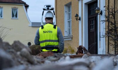
NavVis is a recognized leader in advanced reality capture tech. The company has developed innovative products and applications to capture real-world environments with precision and turn them into complete digital representations, including construction sites.
Utilizing simultaneous localization and mapping (SLAM) systems to generate high-quality data with survey-grade accuracy, NavVis technologies offer unparalleled levels of visualization of construction sites. NavVis VLX is a mobile mapping system that captures comprehensive, survey-grade quality point cloud data and 360° panoramic images of a construction site – even from the very early stages. Reality capture is achieved quickly with high accuracy, regardless of how complex the terrain is.
Spatial data and images are uploaded within seconds via the cloud to the NavVis IVION Core platform, which can be accessed using a standard web browser. NavVis IVION Core is a reality capture platform that can be used by architecture, engineering, and construction (AEC) professionals, as well as surveying and laser scanning. The shareable platform enhances collaboration and enables scanned 3D data to be managed effectively. Data and images can be easily accessed and understood by a range of stakeholders who may not necessarily be experts in BIM or virtual design & construction (VDC).
The technology has been designed to be “software agnostic”, ensuring compatibility with third-party BIM and 3D model visualization tools, clash detection, progress, and cost monitoring programs. This means that all parties involved can work from the same datasets regardless of where they are in the world. Access allows contractors and stakeholders to collaborate openly throughout a project and develop workarounds should problems arise during construction.
Rescanning construction sites enhances transparency across a project for all parties, during and after handover, providing an up-to-date digital representation of a building throughout its lifecycle.
NavVis technology is crucial to this, enabling stakeholders from different disciplines to work together on the same project with ease and accuracy.
For more information on the NavVis VLX mobile mapping system, download the document below.


